Levelling & Straightening in Box: Stanley House and Stoney Steps
Alan Payne Original Idea Roger Oliver February 2020
Alan Payne Original Idea Roger Oliver February 2020
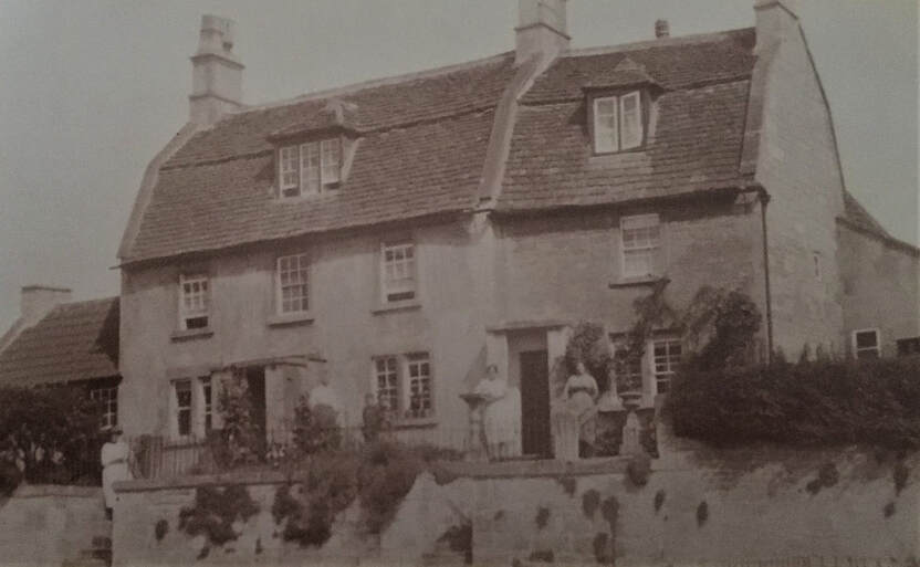
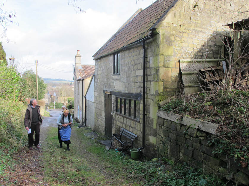
This wonderful photo looks inconspicuous at first glance, just a couple of Box houses and, in some ways, it is rather ordinary.
It shows left to right: Miss Fortune (probably Gladys Fortune, daughter of George and Jane Fortune from 3 The Wharf) on the steps visiting Mrs Sarah Chandler with her grandson Percy Head (known as Jeff) in Stanley House; and Mrs Dermott visiting her relative Mrs Little in Stoney Steps. We can date the photo shortly after 1920 because Percy was born in 1916.
Altering the Road Height
The photo shows the two houses, Stanley House and Stoney Steps, at the current entrance to The Market Place. What makes it unusual is the height of the steps leading to their front doors. It wasn’t always so because the road was once much higher and has been lowered at some point after the houses were built. Charlotte Cottage at the top of Chapel Lane is another instance of a house with a large flight of stairs leading to the front door with the sunken roadway below.
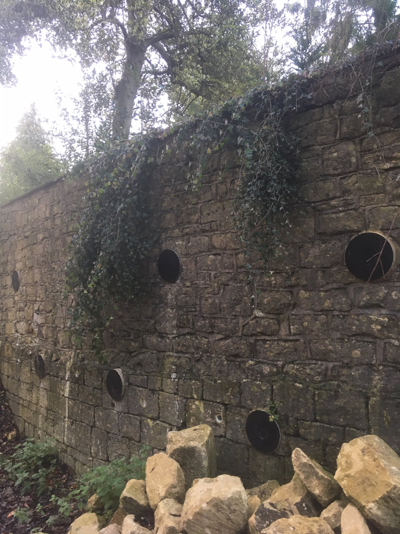
As well as lowering the road surface, there are several instances of the roads being raised in the centre of Box, mostly identified by different layers in their front garden walls. When the road was built up, the front garden wall became too low to be a boundary and additional layers of stone were added on top of the existing structure. The wall of The Hermitage is often quoted as a classic example and, despite the recent collapse of parts of the wall, the two levels are still clearly identifiable. Architectural experts have identified parts of the wall as mid-1700s. It is a Grade II listed structure in its own right, although the listing clearly identifies the upper courses as being different. It is often said that the road was levelled to accommodate stone wagons passing through the village perhaps on their way to the Railway Station stoneyards after 1841.
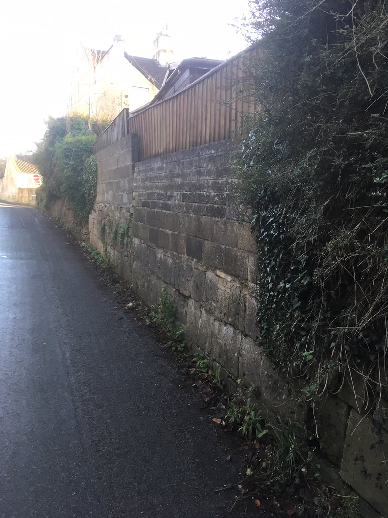
The wall at the top of Mill Lane has also been raised but this appears to have occurred considerably later. There are suggestions that some of the alteration was during the mid-1900s, perhaps due to the increase in traffic using the Lane to equip and service Colerne aerodrome for military purposes at the outbreak of the Second World War.[1]
Above Left: The wall at Mill Lane; and Right: The Hermitage Wall (courtesy Carol Payne)
The Old Roads
There is considerable evidence that roads before modern times weren’t set routes but constantly evolved. The road to Bath is a common example, usually known as The Bath Roads (plural) until the mid-1800s when the routes began to be formalised and a single route preferred. Now, of course, we have gone much further and numbered the roads so that the A4 is the usual traffic route for signposts and Satnavs. It wasn’t always like this. Any rambler will tell of footpaths being blocked by fallen trees or other obstacles and the path winding round the obstruction. In the course of time, the occupiers of adjacent land shifted their land boundaries and the new route became more fixed.
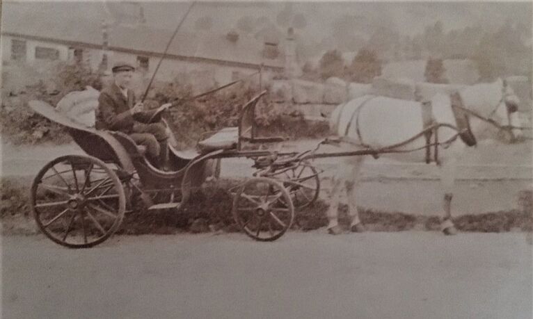
We might conceive of most regular routes as being trackways, probably sunken below the general level of the topographical surface. These were constantly worn away before being re-surfaced with more loose stone and further eroded. Many popular tracks would have ended as holloways, far different to our modern view of defined roads with tarmac surfaces and pedestrian pavements. If one route became difficult to use, another track would emerge nearby. Bends in these routes presented no problem to most horse-drawn carriages and gigs, such as the fly-trap or carriage seen below being driven by Percy Chandler.
Straightening Bends
As road traffic increased so did the chassis-length and weight-bearing capacity of larger carts, carriages and wagons. More than anything, it was low-slung chassis which caused problems. Where needed, new roads were built, such as the 1761 turnpike route from Corsham down to Box. The building of the railway bridge as a viaduct for the road enabled the route to be further straightened and this road was developed as the main route to Box after the mid-1800s with the establishment of Clift Quarry Works, the New School and the Post Office. Going back to the people in the headline photograph, when Sarah’s husband Henry Chandler took over the Manor Farm yard about 1926, he converted the old farm machinery workshops into a car repair garage. This brought greater traffic to the centre of Box and encouraged further road straightening.
As road traffic increased so did the chassis-length and weight-bearing capacity of larger carts, carriages and wagons. More than anything, it was low-slung chassis which caused problems. Where needed, new roads were built, such as the 1761 turnpike route from Corsham down to Box. The building of the railway bridge as a viaduct for the road enabled the route to be further straightened and this road was developed as the main route to Box after the mid-1800s with the establishment of Clift Quarry Works, the New School and the Post Office. Going back to the people in the headline photograph, when Sarah’s husband Henry Chandler took over the Manor Farm yard about 1926, he converted the old farm machinery workshops into a car repair garage. This brought greater traffic to the centre of Box and encouraged further road straightening.
There are numerous examples of road straightening in the very centre of Box. The winding Market Place had long become unsuitable with The Chequers lying deep in a dip often water-logged by a spring which still flows from the modern Jubilee Centre across the road to Coleridge Cottage. When this overflowed it gathered outside the pub which gave the name Frog Lane to the slip road up to Stoney Steps.
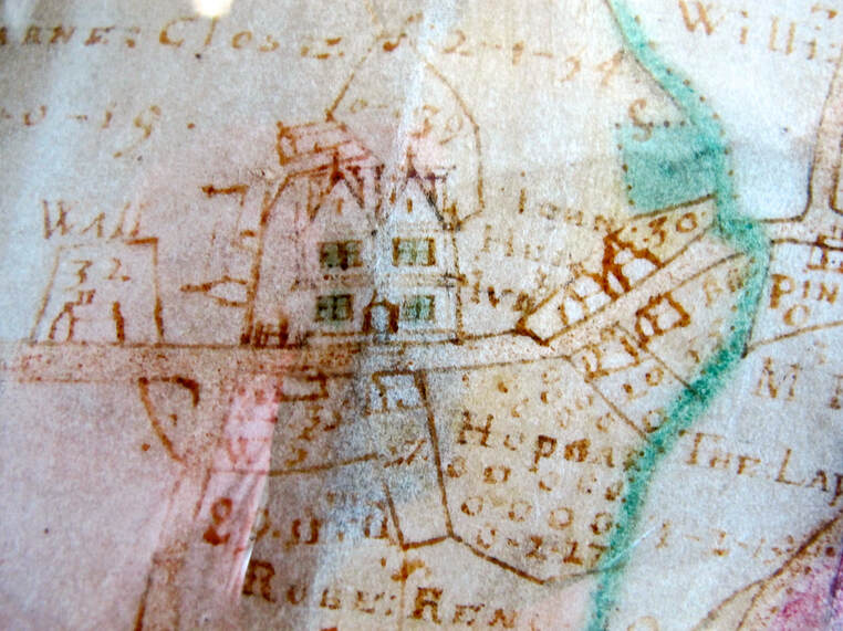
There were other examples of old footpaths falling out of use. The house called Byway behind the current Methodist School on Chapel Lane is indicative of an old road here. You can see this track clearly marked on Francis Allen’s 1626 map where it joins Byway directly to the Queen’s Head. The house is believed to have originated about 1560 and possibly was the ostler’s cottage needed for tending horses at the old coaching inn.[2] This road has now disappeared but another old route is still evident at the top of Chapel Lane. This byway takes a curious winding route up beyond the Lane, past Pye Cottages before looping back on to the Devizes Road at Lyndale.
There were other examples of old footpaths falling out of use. The house called Byway behind the current Methodist School on Chapel Lane is indicative of an old road here. You can see this track clearly marked on Francis Allen’s 1626 map where it joins Byway directly to the Queen’s Head. The house is believed to have originated about 1560 and possibly was the ostler’s cottage needed for tending horses at the old coaching inn.[2] This road has now disappeared but another old route is still evident at the top of Chapel Lane. This byway takes a curious winding route up beyond the Lane, past Pye Cottages before looping back on to the Devizes Road at Lyndale.
Stanley House
And so, we get back to the houses shown in the headline photograph. In 1901 Edward Street, his wife Charlotte and their family lived in Stanley House from where Edward ran a coal and wood merchant business. Their son Stanley was probably born there two years before and it could be that the house was renamed Stanley House from its original unnamed reference Bath Road (although the 1939 Register of residents still referred to the old name). In 1906 Edward and Charlotte’s sixteen-year-old son George, a carter, was prosecuted for driving the vehicle without lights.[3] The case gives an indication of the use of this area. Just along the road (where the Co-op/ McColls now stands) was the exit of the Box Brewery where dray carts pulled out of the business onto the main road. It was obviously a very steep climb but avoided the awkward right-hand turn at the west exit of The Market Place made more difficult by the Pounder Fountain built in 1877.
Edward died in 1907 and the family could no longer afford to rent the house and Henry and Sarah Chandler and their family left Box Hill and moved into Stanley House, running their bakery business from there.[4] Henry and later their son Percy Chandler made horse-drawn deliveries in the area, possibly using the sort of gig shown above.[5] The business faltered during the First World War and Henry and Percy took over the Manor Farm yard operating from there as cab proprietors in 1916.[6]
Stoney Steps
In the next-door house in 1901, sixty-five-year-old Elijah Little, stone mason, and his wife Jane were living at Stoney Steps when the house was simply referred to as on the Bath Road. The 1891 census described them as living on the London Road, the 1881 census described their house as being in Bulls Lane and in 1871 on Chippenham Road. It is possible that all these addresses were Stoney Steps. This branch of the Little family had lived in the village for decades with parents Aaron and Ann.
At first, I thought the headline photo was of Doris Vera Little (born 1900) after her marriage to William Edward Dermott (born 1899) in April 1925 but Doris was from a separate branch of the Little family and her parents were John James and Minniefred Hester Little, who lived in Chapel Lane in 1911. William and Doris still lived locally in 1939 at 4 Bath Road. You can read more about the family in the article Little Family at Charlotte Cottage.
By the 1970s Clement Dyke lived at Stoney Steps. He ran a milk round from The Old Dairy, once the house of the manager of Box Brewery and known as Brewery House but converted into a dairy before 1933 by Clem’s father Henry A Dyke after the Brewery was sold in 1927.[7] His wife Mary died in 1962 and after a few years on his own Clem moved from Box to Llanelli, South Wales.
Of course, once the road has been altered, it is difficult to remember how things were previously. If you think Box is unique in such matters, consider the situation of the city of Seattle, Washington, USA. The city was built below ground level in 1851 but much was burnt to the ground in 1889. New wealth came with a gold rush four years later. The city that remained had entrances built into the second-floor level of houses and a whole street and structure now lies buried beneath the new ground level.[8]
Family Trees
Dyke Family
Henry A (born 10 March 1886) married Alice L (born 27 January 1896). They lived at The Old Dairy (then called Townsend) in 1939 where Henry described himself as milk retailer. Children:
Clement H (20 September 1922-1998) married Mary G Atkins in Dorchester in 1947;
Agnes R (born 31 October 1924)
Chandler Family
John Chandler (b 1827), quarryman and sometimes mason from Bathford, married Ann Head (b 1828) in 1848. They lived at Box Quarries in 1851. After she was widowed, Ann worked as a laundress. In 1871 she was looking after an infant, Joseph Aust (b 1870), living in Townsend (close to Bulls Lane) and calling herself a nurse. Children:
James (b 1849 and working as an 11-year-old page boy to Elizabeth Nash), Ashley House in 1861; Henry (1851-1934); Mary A (b 1853); and Lydia (b 1855).
Henry Chandler (b 1852) started as a stone cutter on Box Hill. By 1881 he had married Sarah Oatley (b 1849) and was earning a living as a baker and grocer at Box Quarries. In 1891 they lived on London Road, next door to Ann, and in 1901 back to Box Hill.
By 1911 Henry was a Cab Proprietor and Grocer. On Box Hill. Children:
Emily Elizabeth (b 1877); Mary (b 1879); George H (b 1880); Frank (b 1882); Cecilia Sarah (b 1884); Arthur Thomas (b 1886); Sydney (b 1888); Percy Stanley (b 1894).
Percy Stanley Chandler (b 1895).
In 1911 Percy was described as shop clerk, apprentice tailor - outfitting.
References
[1] Courtesy Alan Clench
[2] Courtesy Mary Finch
[3] The Bath Chronicle, 15 March 1906
[4] The Wiltshire Times, 25 March 1916
[5] Wiltshire Times and Trowbridge Advertiser, 2 November 1901
[6] Wiltshire Times and Trowbridge Advertiser, 8 January 1916
[7] Bath Chronicle and Weekly Gazette, 8 July 1933
[8] Courtesy Jennifer Payne
