Roman Roads in Box Alan Payne December 2020
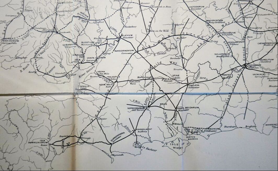
Extract of map of Roman roads in south of Britain (source unidentified)
The Conquest of the South West
Why did Box have two straight Roman Roads specially built in the area? And why were they constructed in what appears to be the wrong place for our understanding of normal daily life for Box Roman villa? The roads mark two boundaries of the present parish on the south and west of our area. It doesn’t seem to make sense until we look at the early history of the area in the Roman period.
The answer goes back to the very early years of the Roman Conquest, not the investigation by Caesar in 55-54BC but in the decades after the settlement led by Aulus Pautius in the reign of Claudius in 43AD in the east of England.[1] A second stage of the invasion was commanded by Vespasian from the Isle of Wight and pushed north to take the Dorset hillforts of Maiden Castle and Hod Hill (near Blandford Forum) and the Somerset fort at South Cadbury. It would be reasonable to assume that the hill forts resisted the Legio II Augusta as did the established population of Wiltshire.
|
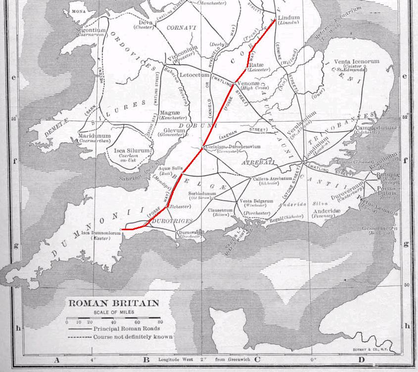
Fosse Way
To establish control the Romans quickly built military supply roads, an important one being the Fosse Way from Lyme Bay to Lincoln. The road was named after the ditch (fosse) next to the road which was a defensive embankment. It is believed that the ditch was originally the boundary of the Roman province in Britain in the years approximately 43 to 68AD. The Fosse frontier was established early by 47AD but was later abandoned when land to the west was brought under control.[2] The road is closest to the modern Box parish between Batheaston and Alcombe, which means that in the early years Box was just inside the Roman province, but only just. Left: Fosse Way (courtesy of Wikipedia) |
The area they took over may have been populated with Celtic villages in the lowlands as well as ridge settlements but little evidence of this has been found in Box.[3] The region was soon brought under civil administration with civitas capitals, run by wealthy landowners, which in the case of our area meant administration from Bath. In the period up to about 250AD more than twelve villas have been found in the area, including those at Atworth, Colerne, Bradford-on-Avon and North Wraxall.[4]
Via Julia
The second road still forms the southern boundary of the parish, reflecting its importance. It runs east-west past Norbin Farm and Hatt Farm to Ashley Wood, where its track is lost. Only remnants of the embankment and road surface now survive in the local area but it is still known in places. Sometimes it can be seen as a continuous hedge-line; sometimes it follows a line of electricity pylons. It runs on high ground with views of thirty kilometres across open countryside to South Wraxall and Westbury. The road is often over five metres wide, at Neston Park it is over 13 metres. A well-preserved part is at Closes Farm, where it is one metre high and six metres wide. In its heyday, it was on a raised embankment up to two metres high, with ditches either side for drainage. In places there is evidence of the layering of the road with a foundation layer of large stones, then a surface layer of smaller stones, probably for bonding.
The road is part of the Via Julia from Mildenhall (then called Cunetio 1 mile east of Marlborough), to Bath. Mildenhall was one of the main junction hubs in the area, connecting routes from Winchester, Old Sarum and Silchester.[5] In 1978 one of the largest hoards of Roman coins in Britain was discovered in Mildenhall amounting to 55,000 coins dating from the period 250-275AD. This route is probably later than Fosse Way and reflects the volume of traffic going to visit Bath.
The road appears to have been for military purposes and may have been in use in the turbulent years of the late 200s when Carausius declared himself emperor in Britain and north Gaul (286-293). There is some evidence that Carausius was active locally because another hoard of coins discovered in 2010 at Frome were produced during his reign.
|
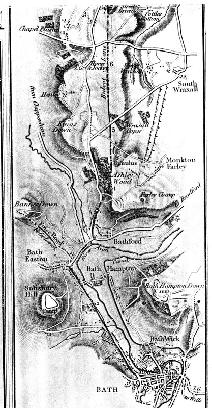
Sir Richard Colt-Hoare's Discovery We know that the Roman road continued in use for centuries after the fall of their empire. It was a boundary marker to define land-holdings, a broad strip of land belonging to no one and not ploughed. Some idea of its importance can be seen from the writing of Sir Richard Colt-Hoare when he visited the area in October 1819:[16] FIND We ascertain it precisely (when) we reach Ashley Wood, where its elevated ridge becomes visible, having a stone quarry on each side of it, and forming a boundary between the parishes of Box and Monkton Farley. There was a tradition amongst the country people, that the Roman causeway was passable through the fields, and admitted loads of corn to have been carried upon it. At the extremity of the last-mentioned field, the elevated bank is overgrown with copse wood; and here, on stepping across it, we found its span measured thirty feet ... we noticed a trench cut on the South side of the road almost wide enough to admit a cart, which cavity is denominated Bulcot Lane... We walked along Bulcot Lane (or trench, to the South of it), where we met with some large stones fallen into the trench, which seemed to corroborate our former opinion, that they had originally formed the lower stratum of the causeway... The Roman way is now crossed by a modern road from Corsham to South Wraxall, at the extremity of Bulcot Lane ... The elevation of the causeway still continues visible through the fields, where it is not much more than eight feet wide, owing to its having been destroyed for the sake of materials. Left: Extract of map by Sr Richard Colt-Hoare |
Finds on the Via Julia
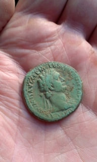
A variety of coins has been found on the Via Julia in the area of Hatt Farm. The earliest was a coin dating from the reign of the Emperor Domitian, a cruel tyrant who abolished the Roman Republic and was himself assassinated. As well as the battles in Britain fought by his general Agricola, Domitian’s possible connection with the area was that he worshipped the goddess Minerva, whose name was associated with Bath as Sulis Minerva. Also found was a silver denarius from the reign of Antonius Pius, Emperor from 138 to 161AD. Antonius followed Hadrian as Emperor and he built the Antonine Wall, imitating the wall of his predecessor. His reign was largely peaceful and the wall was more indicative than defensive.
A variety of coins has been found on the Via Julia in the area of Hatt Farm. The earliest was a coin dating from the reign of the Emperor Domitian, a cruel tyrant who abolished the Roman Republic and was himself assassinated. As well as the battles in Britain fought by his general Agricola, Domitian’s possible connection with the area was that he worshipped the goddess Minerva, whose name was associated with Bath as Sulis Minerva. Also found was a silver denarius from the reign of Antonius Pius, Emperor from 138 to 161AD. Antonius followed Hadrian as Emperor and he built the Antonine Wall, imitating the wall of his predecessor. His reign was largely peaceful and the wall was more indicative than defensive.
|
|
Soldiers in the Area
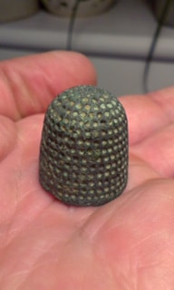
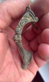
There are some finds relating to the marching of soldiers on the Via Julia. Below is a dice, commonly used for recreation in the Roman army, a Roman thimble for soldiers to mend tunic, sandals and equipment and a broach. (These photograph courtesy
Box NATS History Trail walkers)
There are some finds relating to the marching of soldiers on the Via Julia. Below is a dice, commonly used for recreation in the Roman army, a Roman thimble for soldiers to mend tunic, sandals and equipment and a broach. (These photograph courtesy
Box NATS History Trail walkers)

|
|
|
Impact of the Roads
Clearly the Roman roads are predominantly straight and, as such, went right through the existing territorial boundaries. Unfortunately, we can’t reconstruct previous territories which have since been distorted by Saxon land acquisition and the redrawing of territories now recognised by the meandering tracks which typify Saxon roads.[6]
The Roman roads highlight how separate Box village was from national routes. The roads didn’t join our area to the rest of the country, rather the routes bypassed us. The Romans ran their roads through a high point in open land, with broad views of the surrounding area. The village lies in an entirely different topography, far away in a steep grassy valley where the fast-running By Brook has cut into soft rock at the valley bottom leaving harder limestone in the surrounding hills of Ditteridge, Kingsdown and Hazelbury.
The old Celtic trackways were used for the villa’s needs and for other local traffic, probably as they had been for centuries before. The Roman roads made little difference to this.
References
[1] Victoria County History of Wiltshire, Vol 1 Part 2, Editor RB Pugh, 1973, Oxford University Press, p.439
[2] Victoria County History of Wiltshire, Vol 1 Part 2, Editor RB Pugh, 1973, Oxford University Press, p.440
[3] Victoria County History of Wiltshire, Vol 1 Part 2, p.445
[4] Victoria County History of Wiltshire, Vol 1 Part 2, p.449
[5] Victoria County History of Wiltshire, Vol 1 Part 2, p.440
[6] Francis Pryor, The Making of the British Landscape, 2010, Penguin Books, p.170