What and Where Am I? Suggested by Stephen Eyles and Varian Tye July 2021
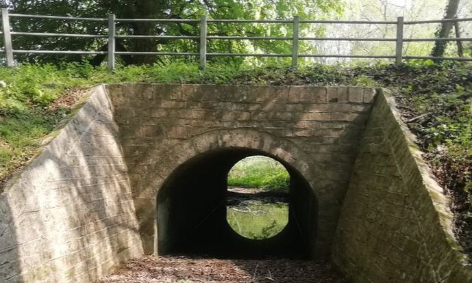
Where was this photograph taken? Here are a few clues which raise even more questions (photo courtesy Varian Tye)
When you walk through Box village and its surrounding areas you will often be on an embankment with land sloping away on either side. Of course, this relates to the undulating nature of Box’s topography and the frequent springs which have gouged out valleys in the area. The most obvious place to see this phenomenon is on the A4 road passing Box School where the embankment was built for a different reason - to bypass the Market Place and raise the road level for a bridge over the railway line.
The way in which the village developed was considerably affected by these varying road levels. As early plots were acquired, developers concentrated on the more level plateaus, which left more difficult levels for later enclosures. As a result, there was no planned grid building project until the Bargates development after the Second World War. Before then, the best that speculative builders could do was to construct a small rank of houses, sometimes at right angles to existing development lines such as at Fairmead View. This was usually supplemented by building on individual plots, characteristic of Box Hill properties.
Origins of the Culvert
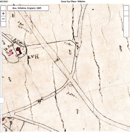
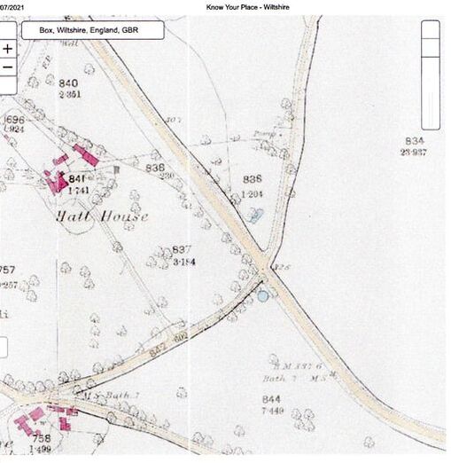
It is almost impossible to determine the history of the culvert. The 1840 Tithe Apportionment map (below left) appears to show some form of structure in the area of the culvert identified on the map as two closely-set parallel lines, narrower than a bridge, with a cross on it. It appears below the field division line to Hatt House. The 1844-1888 Ordnance Survey map (below right) show no sign of a culvert or bridge on an embankment.
It is almost impossible to determine the history of the culvert. The 1840 Tithe Apportionment map (below left) appears to show some form of structure in the area of the culvert identified on the map as two closely-set parallel lines, narrower than a bridge, with a cross on it. It appears below the field division line to Hatt House. The 1844-1888 Ordnance Survey map (below right) show no sign of a culvert or bridge on an embankment.
|
|
Above left: the 1840 Tithe Apportionment map and Right the 1844-1888 Ordnance Surveys (both courtesy Know Your Place)
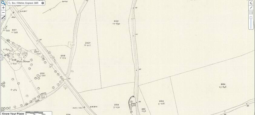
The 1898-1939 Ordnance Survey map (below) is the first time that a clear recess in the embankment either side is shown, reflecting the culvert bridge that exists today.
The 1898-1939 Ordnance Survey map (below) is the first time that a clear recess in the embankment either side is shown, reflecting the culvert bridge that exists today.
Conclusion
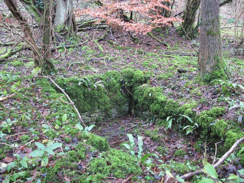
Back to the headline photograph, the structure which exists today appears to have once bridged a stream or spring. It is an expensive structure, maybe once high enough for a horse and carriage to pass underneath. It is possible that, prior to the turnpike road being built in the years 1831-41, the farmland belonging to Hatt House included the land noted as reference 258 as well as 256 and 257. After the road was built, a bridge under the embankment would have provided a more direct link between the farm land on either side of the road for animals and people.
Back to the headline photograph, the structure which exists today appears to have once bridged a stream or spring. It is an expensive structure, maybe once high enough for a horse and carriage to pass underneath. It is possible that, prior to the turnpike road being built in the years 1831-41, the farmland belonging to Hatt House included the land noted as reference 258 as well as 256 and 257. After the road was built, a bridge under the embankment would have provided a more direct link between the farm land on either side of the road for animals and people.
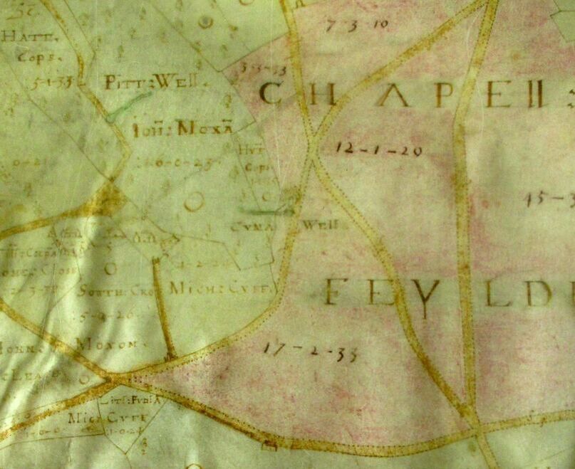
There are other strange remains in the area: to the north what appears to be the remains of a well (called CUMA WELL in Allen’s 1626 map above, courtesy Wiltshire History Centre) and, a short distance to the south of the underpass, the submerged stone structure seen below (courtesy Carol Payne).
Can anyone help explain these costly constructions? In case you haven’t identified the location, the culvert is at the top of the Devizes Road a short distance before Short Hill (the crossroads between the Old Jockey and Hazelbury House).
Any suggestions about these curious structures would be much appreciated.
Any suggestions about these curious structures would be much appreciated.