The Cartographic Allens
Box’s Earliest Map-makers Jonathan Parkhouse March 2023
Box’s Earliest Map-makers Jonathan Parkhouse March 2023
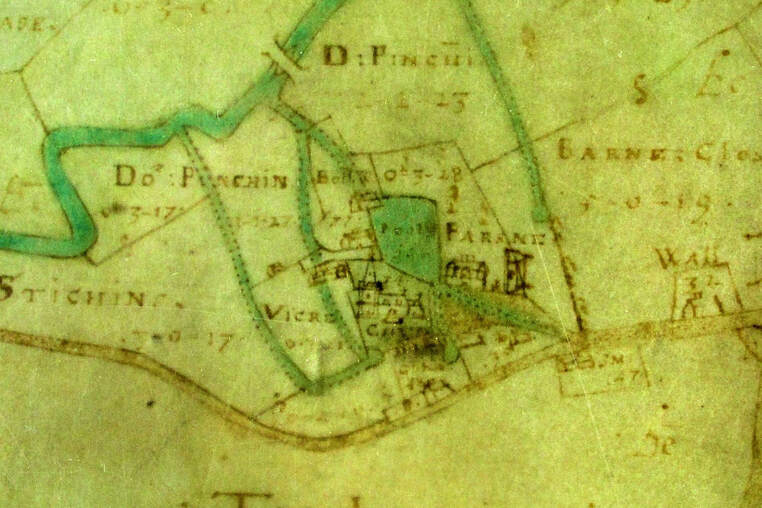
Box Church, Becket’s Mill and fields marked for the vicar and for the parson.(courtesy Wilts History Centre). The catalogue describes the map as "Large watercolour map, with buildings in perspective and elevation described as "The: Plot: And: Survaye: Of: The: Mannors: Hayselbury: Box; And: Ditchredg: Taken Ano 1626 by me Abrah. Alen". Compass rose. Scale: sixteen inches : one mile
The seventeenth century was a boom time for the surveying profession, with the number of practising surveyors rising from about 225 in 1600 to around 850 by 1660.[1] At the start of the seventeenth century formal instruction in mathematics and applied science was almost negligible; most instruction in surveying was either private or via apprenticeship.[2] As the seventeenth century progressed, advances were made in geometrical teaching, logarithms, which made the multiplication of numbers with many digits easier, were discovered, trigonometry introduced into the university curriculum, and new surveying instruments developed. Concurrent with this was a growing consciousness of the role of maps in the management of landed estates. The shift from feudalism to capitalism meant that land was increasingly seen as a commodity; monetary value could be placed on specific parcels of land and maps became a useful means of demonstrating exclusive rights to land. In addition, cadastral maps (that is maps which showed individual land parcels) became a symbolic representation of the landowner’s control of the means of production.[3] An estate map was thus a status symbol as much as an aid to management. The map, unlike a written description or terrier, could identify property boundaries permanently, even when there were changes to the landscape of baulks and hedges.
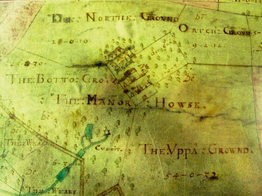
Hazelbury Manor, the basis of the Speke power possibly showing a chapel fed with water (courtesy Wilts History Centre)
A number of cartographers with the name Allen were active in the seventeenth century,[4] including the two known to have worked in Box for the Speke family: Abraham, who produced a map of Speke’s lands in Hazelbury, Box and Ditteridge in 1626, along with additional maps showing four of the remaining open fields in greater detail, and Francis, who produced an additional version of the main estate map, correcting a few errors of Abraham’s, in 1630.[5] It is likely that the impetus for the maps was the inheritance of the Box estate by George Speke upon the death of his father Hugh in 1625. Commissioning a map enabled George to understand what he had inherited; a fine watercolour map, perhaps displayed on a wall, was a ready means of displaying his status.
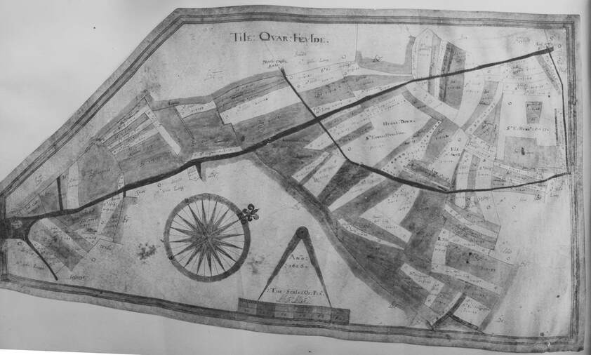
Abraham Allen's 1626 "Tile Quar Feylde" map (courtesy Wilts History Centre)
Abraham Allen
Abraham Allen undertook work on manors and estates in Essex, Kent, Leicestershire, Oxfordshire and Wiltshire between 1609-38, including work for the Crown.
Elias Allen
Elias Allen, born c. 1575, active from 1601 and deceased by 1637 undertook work across southern England.[6] In 1616 he was living in Spelsbury Oxfordshire, but by 1624 he was described as being of “Melton’, probably Milton, Cambridgeshire.[7] He too undertook work for the Crown. He worked with Abraham Allen on a series of maps for Merton College, Oxford in the 1620s and 1630s.[8] By this point they seem to have been established surveyors who had already undertaken work for the Crown. Elias Allen’s map of the college’s land in Malden was produced as evidence in a successful litigation, which apparently prompted Merton College to engage Elias to survey the college’s Surrey estates in Leatherhead and Farleigh. By 1630 his pay had been doubled. He was succeeded by Abraham Allen, who worked on the College’s Essex, Kent and Leicestershire estates. Abraham’s work for Merton was evidently more elaborately decorated than that of Elias, although there were occasional inaccuracies.
Confusingly, there is another Elias Allen of the period (c. 1588-1653) who worked as a scientific instrument maker, but although he also came from the Tonbridge area there is no evidence that he was related.[9] The survival (in a copy by Wenceslaus Hollar) of a contemporary portrait is indicative that his social standing was higher than that of a mere cartographer; he had been an associate of many of the leading mathematicians of the day, such as Edward Gunther, who invented the surveyors chain (or at any rate the version of it which was to become the industry standard), had made instruments for both James 1 and Charles 1, and was Master of the Clockmakers’ Company in 1637-38. The increased amateur interest in pure and applied science meant that his instruments found a market. His biographer specifically states that he was "the first English instrument maker not to be forced to supplement his income by engraving maps or practising as a surveyor".[10]
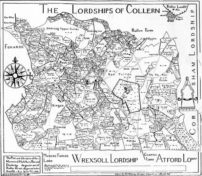
The Francis Allen map of 1630 was transcribed by Thomas Holloway in 1907 (courtesy Wilts History Centre)
Francis Allen
Francis Allen, active 1646-76, if not earlier, assuming he is the Francis Allen responsible for the 1630 Box map, created estate maps in Cheshire, Derbyshire, Lincolnshire, Shropshire, Wiltshire and Worcestershire; if related to the other Allens he probably belonged to the next generation to Elias and Abraham.
Henry Allen
Henry Allen or Allin/Alleyn of Tonbridge, Kent was active by 1599.[11] His will is dated 1627.[12] Described as an almanac-maker, and also as a land surveyor, he made estate maps in Kent and Sussex, including a number of maps in the Lamberhurst area. His maps are carefully drawn, in sepia, eschewing all other colouring and indicating orientation in the borders of his carefully-drawn maps rather than by the usual compass-rose.[13] Interestingly, an Elias Allen was one of the witnesses to a codicil to Henry’s will, although he was not named as a beneficiary, the bulk of Henry’s estate being left to his wife, his married daughter and her children.[14]
Insofar as we may reconstruct the genealogy of the cartographic Allens, we can point to a probable connection between Henry and Elias although it seems more likely that Elias was a more distant relative (nephew? cousin?), and definite connections between Francis and Abraham (since they both did work in Box) and between Elias and Abraham (who were both employed by Merton College).[15] On the basis of the admittedly scanty biographical information, Henry seems to have been the first Allen surveyor, Elias and Abraham possibly brothers, and Francis the next generation, possibly the son of Abraham. However, this would indicate that Francis had a very long career; it is not impossible that there were two individuals with that name, particularly in an age when individual families chose their Christian names from a very short list, and close relatives might have the same name.
References
[1] Eden P (ed) (1979) Dictionary of land surveyors and local cartographers of Great Britain and Ireland, 1550-1850 / compiled from a variety of sources by Francis Steer (Folkestone) fig 12 p28.
[2] Richeson AW (1966) English land Measuring to 1800: Instruments and Practices. (Society for History of Technology and Massachusets Institute of technology, Cambridge, Mass, USA), esp. pp.90ff.
[3] Kain RJP (1997) ‘Mapping landed properties: medieval renaissance and enlightenment England’ in C Delano Smith & RJP Kain (eds) La Cartografia Anglesa (Institut Cartogràfic de Catalunya, Barcelona), 129-144.
[4] Bendall S, (1997) Dictionary of land surveyors and local map-makers of Great Britain and Ireland, 1530-1850 (London, British Library), Vol 2, pp7-8
[5] Wiltshire and Swindon History Centre: 318/2H; 318/3ms. Only the main 1626 map is original; the others are photocopies made at some point before 1955 of maps in private hands; their current location is unknown and the photocopies are not of the highest quality. An early twentieth century drawn copy of Francis Allen’s 1630 map, not necessarily entirely accurate, was reproduced by George Kidston in his History of the Manor of Hazelbury (1936)
[6] Hull, F (1992) ‘Kentish map-makers of the seventeenth century’, Archaeologia Cantiana 109, 63-83 states that Elias Allen was born in Kent and died in 1654, and is known by a copy of a map of Faversham of c1650; he worked in Berkshire, Surrey, Gloucestershire and Oxfordshire; this information is also in Eden Dictionary of Surveyors
[7] Bendall S (2000) ‘Merton College and the mapping of its estates, 1601-1836’. Oxoniensia 65, 79-110
[8] ibid
[9] Higton HK (2008) ‘Allen, Elias’ Dictionary of National Biography https://doi.org/10.1093/ref:odnb/37108
[10] The British Sundial Society website (http://sundialsoc.org.uk/discussions/glossary-a-z/34/) suggests that he may have undertaken estate surveys when young, but in the absence of any supporting evidence one may conclude that this assertion is the result of confusion between the two Elias Allens.
[11] Dates given in Eden are 1603-18
[12] National Archives PROB 11 /152/513
[13] Hull loc cit note 6.
[14] Transcript of Henry Allen’s will at http://vulpeculox.net/history/wkw2016/pdf/V2AB.PDF, pp 2.a.33-44
[15] Other individuals with the surname Allen also made maps and may or may not have been relatives. George Allen is known from a single estate map in Lincolnshire. Mich(?ael) Allen created a map of an estate in Buckinghamshire in 1637. A Patrick Allen was responsible for a number of projects in Ireland in the 1650s.